
North Carolina is a state of dramatic contrasts. On the Western edge, you can be exploring mist-shrouded mountains, in its heart, dense forests and lush farmlands spread out, and in the East, the windswept barrier islands stretch toward the Atlantic.
It’s one of the USA’s most scenic states, and what better way to learn that than on a road trip? Since we moved to North Carolina over a decade ago, we’ve explored much of the state by following its scenic roads.

Our favorite scenic drives in North Carolina are the ones that go beyond the interstates and into the heart of these landscapes — through winding forest roads that dazzle in Autumnal colors, meandering along river bends, and past coastline vistas. Each route has shown us how diverse our home-state is. Behind these scenic drives is not just nature in full glory, but also historic towns, cute coastal towns full of maritime culture, and mountain towns where the craft beer is as good as the hiking trails.
If you want to explore North Carolina’s best driving roads, below are the ones that invite you to slow down, pull over, and truly see what makes this state remarkable.
Scenic Drives in the North Carolina Mountains
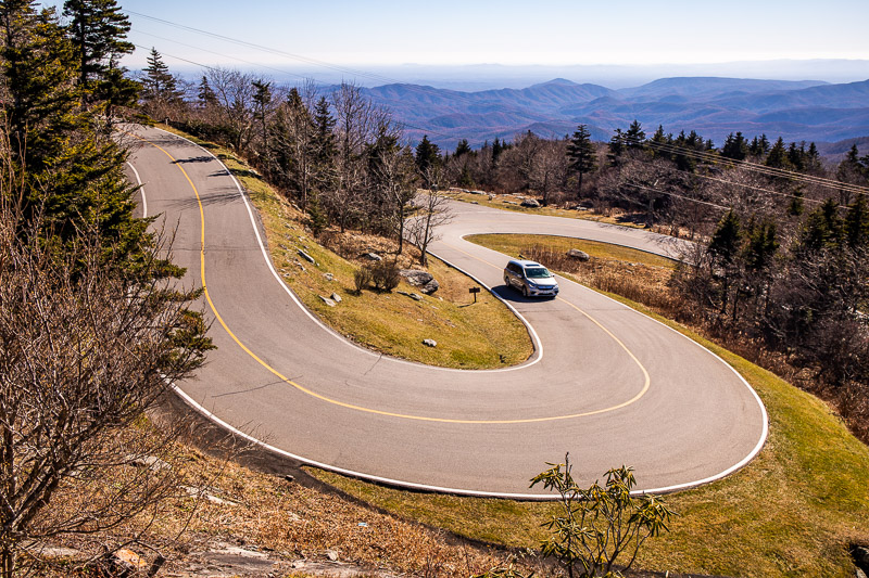
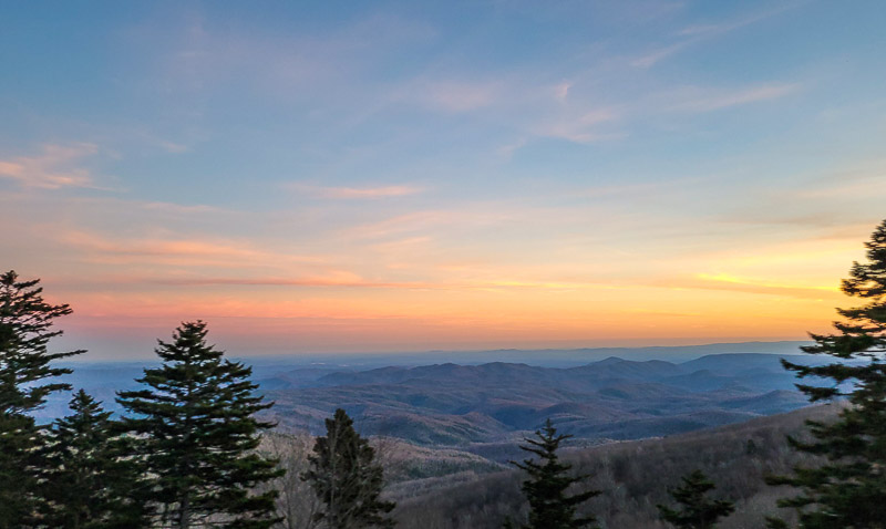
The Blue Ridge Parkway
- Length of road: 252 miles (the North Carolina portion only; the full parkway is 469 miles from Virginia to North Carolina)
- Recommended time to complete: 4 – 5 days
- Start/End Point: Virginia–North Carolina state line near Galax, VA | Cherokee, NC (at the entrance to Great Smoky Mountains National Park)
- Best season to drive: Fall (late September–October) for peak Fall foliage colors and clear mountain views; or spring (April–May) for cool temperatures and wildflowers
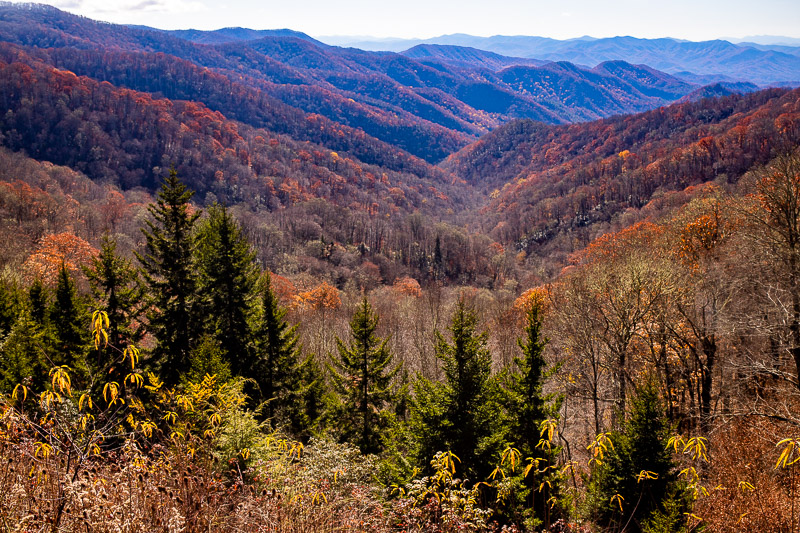
The crown jewel of driving roads in North Carolina is undoubtedly the Blue Ridge Parkway. Running 252 miles through the North Carolina Mountains, this legendary road delivers nonstop mountain vistas, access to some of the best hiking trails in the state, jaw-dropping waterfalls, and fascinating historic sites.
It’s one of our favorite roads for Fall foliage as it passes through both Shenandoah National Park in Virginia and the Great Smoky Mountains in NC, both known for their biodiversity and variety of tree life. We’ve driven the Blue Ridge Parkway in stages, using Asheville as our gateway. Some of our favorite stops along the route are Linn Cove Viaduct, Linville Falls, and Grandfather Mountain, Mount Mitchell State Park, Blowing Rock, Craggy Gardens (for rhododendron-filled views), Mount Pisgah, and the Smokies, of course.
The Tail of the Dragon (US 129)

- Length of road: 11 miles (the famous stretch features 318 curves)
- Recommended time to complete: 1 day. It takes 30 – 45 minutes without stops, but allow extra time for pull-offs, photos, and traffic (especially on weekends)
- Start/End Point: Deals Gap, NC (near the NC–TN border) | Chilhowee Lake / Tabcat Bridge area, TN (within Cherokee National Forest)
- Best season to drive: Spring (April–May) and fall (September–October) for mild weather and clear roads. Summer has heavy traffic, especially motorcycles, and in the winter, the road may be closed due to ice and snow.
If you’re a motorbike enthusiast, or fancy testing your rally car skills, then the Tail of the Dragon Road, which runs along the North Carolina/Tennessee Border is the most famous driving route for actual driving. It’s famous for having 318 curves in 11 miles (stock up on motion sickness meds if you’re a passenger), but it’s also as scenic as it is thrilling.
It carves through the dense forest and mountain terrain of the Great Smoky Mountains and has no intersections or driveways, so it’s straight up driving with the odd overlook thrown in to break up the bends.
For bikers, it’s known to be technically difficult and has a few corner names that sound a little ominous – Copperhead Corner, Wheelie Hell, Gravity Cavity, and my personal favorite, Brake or Bust Bend, which requires a bit of focus to drive around. Still, if you want a road that’s thrilling and framed by gorgeous woodland, this is it. Although considered dangerous, there is a 30-mph speed limit, and the amount of traffic does stop you from driving too fast, so it’s not as risky as it once was.
Great Smoky Mountains Scenic Byway (US 441)
- Length of road: 31 miles
- Recommended time to complete: half a day to a day. It takes 1–2 hours without stops, but plan for longer to include stopping at overlooks and doing short hikes.
- Start/End Point: Cherokee, NC | Gatlinburg, TN
- Best season to drive: Spring (April–May) for wildflowers and wildlife viewing, and Fall (October) for foliage. Winter often has closures at Newfound Gap.
The Great Smoky Mountains Scenic Road, also known as Newfound Gap Road, is a short scenic stretch that links the town of Cherokee in the South to Gatlinburg in the North, passing through the Great Smoky Mountains National Park.
This drive offers misty peaks, elk sightings, and access to some of the most biodiverse landscapes in the eastern US. Reaching an elevation of 5,046 feet above sea level, it’s one of the best roads for views over the treetops of the Smokies, and getting that iconic view of the blue haze that drapes across the treetops.
It’s heavily trafficked, since most people visiting the Smokies will find themselves on this road at some point, but there are so many stops that it doesn’t feel congested. Unlike the Tail of the Dragon road, this road is more about the stops than the actual route (although the views are amazing).
Some notable stops along this route are the Oconaluftee Visitor Center, overlooks at Newfound Gap and Kuwohi (formerly known as Clingmans Dome), the Chimney Tops hike, and Sugarlands Visitor Center.
Read More: How to enjoy a weekend in the Great Smoky Mountains and things to do in Bryson City
Cherohala Skyway (NC 143)

- Length of road: 43 miles total (approximately 20 miles in North Carolina)
- Recommended time to complete: allow half a day to enjoy overlooks, picnics, and short hikes, but it takes 1-2 hours to drive without stopping
- Start/End Point: Robbinsville, NC | Tellico Plains, TN
- Best season to drive: Late spring through fall (May–October) for clear views and best temperatures
Another mountain road in North Carolina with sweeping views, long curves, and a remote feel is the Cherohala Skyway, which connects Robbinsville to Tellico Plains.
It’s known for having several hiking trails along the route, most notably the Huckleberry Knob hike, an easy 1.8-mile hike in Nantahala National Forest that takes you to a viewpoint with 360-degree views. Other notable stops are Bald River Falls, Hooper Bald, and Joyce Kilmer Memorial Forest to see ancient hemlock and poplar trees. It’s close to the aforementioned Tail of the Dragon Road, so you could easily combine both these scenic roads in one trip. Note: There are no services on this road (no gas stations, restaurants, or hotels).
Forest Heritage Scenic Byway

- Length of road: Approximately 76.7 miles
- Recommended time to complete: allow 1 day. It takes 2–3 hours without stops, but allow more time to explore waterfalls, hiking trails, and historic sites.
- Start/End Point: Near Brevard, NC (US 276 at the entrance to Pisgah National Forest) | Near Rosman, NC (US 64)
- Best season to drive: Spring and summer for more powerful waterfalls and lush forest scenery
In Western North Carolina, the Forest Heritage Scenic Byway is a lesser-known offshoot of the Blue Ridge Parkway, winding past waterfalls, hiking trails, and historic logging sites in Pisgah National Forest.
Again, it’s another road we’ve entered on without realizing it while driving the Blue Ridge Parkway but discovered it while taking a detour to Looking Glass Falls. We’re so glad we did, as it had lots of great hiking trails and waterfalls to stop off at. An unexpected gem was Sliding Rock, a natural waterslide where you can slide down a smooth rockface into a refreshing pool below.
This is one of NC’s oldest logging railroad routes, but it has been largely reforested, and you can see new trees thriving along the Pink Beds Loop Trail. Be sure to stop by the Pisgah Visitor Center before you drive to learn more about this region’s history and the best waterfall stops.
Read More: Waterfalls in North Carolina that look like Bali
Piedmont & Central North Carolina Scenic Drives
Yadkin Valley Scenic Byway

- Length of road: Approximately 63 miles
- Recommended time to complete: 1 day to visit wineries, small towns, and river viewpoints, but can be driven in 1.5-2.5 hours without stops
- Start/End Point: Elkin, NC | Near Pilot Mountain State Park, NC
- Best season to drive: Spring for blooming vineyards and mild weather; Fall for harvest season and the Yadkin Valley Grape Festival.
Moving away from mountains and into rolling farmland filled with vineyards and wineries, the Yadkin Valley Scenic Byway is a relaxed drive through North Carolina’s wine country (yes, there is one). As NC’s premier wine area, you can expect most attractions to be based around Vino. Some of the most notable wineries on route are Shelton Vineyards, Divine Llama Vineyards (great for kids as it’s also a llama farm), Haze Gray Vineyards, Sanders Ridge, Adagio Vineyards, and Piccione Vineyards.
Most wineries have vineyard tours, and you can also learn more about wine in this region at the Yadkin Valley Grape Festival held every year in October, if you can plan your visit for then.
Pilot Mountain Scenic Drive

- Length of road: 10-mile loop
- Recommended time to complete: 1 day to visit overlooks, hiking trails, and nearby towns
- Start/End Point: Pinnacle, NC
- Best season to drive: spring (April–May) for fresh greenery and wildflowers.
This is a short but striking route circling Pilot Mountain State Park. The road allows you to drive close to the iconic Big Pilot rock formation, offering dramatic views, and provides access to the park’s many hiking trails. If you want to get out of the car and enjoy a hike, then we recommend the Jomeokee Trail, a short hike that surrounds Pilot Mountain’s Big Pinnacle. This scenic drive also easily connects to the Blue Ridge Parkway.
Uwharrie Scenic Road (NC 109)

- Length of road: Approximately 20 miles through the heart of Uwharrie National Forest
- Recommended time to complete: half a day to explore lakes and hiking trails
- Start/End Point: Troy, NC | Near Badin Lake / Denton area, NC
- Best season to drive: Spring for wildflowers; fall for foliage. Summer is lush but hot and humid.
In Central North Carolina, one of the state’s oldest mountain ranges, is the Uwharrie Mountains. This scenic road winds peacefully through the Uwharrie National Forest, which is rich in wildlife and has an off-the-beaten-path charm. Although the road is short, it has a lot of attractions attached to it. You can go hiking, mountain biking, horseback riding, or take a four-by-four along an off-road vehicle trail.
Uwharrie National Forest made our list of most underrated destinations in North Carolina on our Raleigh site.
Coastal & Eastern North Carolina
Outer Banks Scenic Byway (NC 12)
- Length of road: Approximately 138 miles (including ferry connections along NC 12)
- Recommended time to complete: 1–2 days is ideal, but factor in ferry schedules. Driving time without stopping is about 3–4 hours.
- Start/End Point: Whalebone Junction, Nags Head, NC | Cedar Island, NC (via ferry connections through Ocracoke)
- Best season to drive: Late spring (April–May) and early fall (September–October) for warm weather, fewer crowds, and calmer ferries
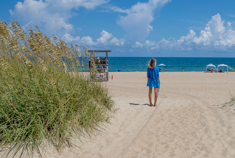
We love the Outer Banks; it’s one of our favorite regions in North Carolina. Although a series of barrier islands, Highway 12 and a few ferry crossings link them together, forming one epic coastal journey connecting lighthouses, wild beaches, ocean and sound views, and historic villages. Some of our favorite stops on this route are Pea Island Refuge, Cape Hatteras State Park, and Ocracoke Island. It’s a journey through unspoiled natural beauty and is soaked in small beach town vibes.
Cape Hatteras National Seashore Drive

- Length of road: Approximately 67 miles
- Recommended time to complete: 1 day, it takes 2–3 hours without stopping, but you will want to stop to explore beaches, lighthouses, villages, and wildlife areas.
- Start/End Point: Bodie Island Lighthouse (near Nags Head), NC | Ocracoke Village / Hatteras–Ocracoke Ferry terminal, NC
- Best season to drive: May to November (closed in the winter)
Speaking of Cape Hatteras, if you want to take an elevated coastal drive, then you should get yourself a four-wheel drive and hit the Cape Hatteras National Seashore Drive, a beach drive in the Outer Banks. This drive passes epic sand dunes, maritime forests, and iconic lighthouses.
You do need a permit to drive this “road,” and a bit of careful planning is needed beforehand, as some parts of the road may be closed due to tides. Some of the road is also inaccessible during the breeding seasons of protected birds and sea turtles, so check the website before your trip to see if there are closures.
Pamlico Scenic Byway

- Length of road: Approximately 122.1 miles (including multiple ferry crossings)
- Recommended time to complete: 1–2 days is ideal, allowing time for ferry schedules, coastal towns, and wildlife refuges. The driving time without stopping is about 4–5 hours
- Start/End Point: Washington, NC | Cedar Island, NC
- Best season to drive: Summer is scenic, but can be hot and humid with occasional storms. Aim for Spring for mild temperatures and clearer skies.
Combining history, nature, and small town charm, the Pamlico Scenic Byway is a watery, ferry-heavy route through fishing villages and coastal wetlands. The name Pamlico was given to the route after the name of a Native American tribe that once lived in this region, though it was also colonised by Europeans in 1584. It passes through small towns that reflect this colonial history and a series of wetlands and forests.
Some of the most notable stops on this route are Washington, also known as Little Washington (except not to the locals, they hate it), the Pamlico Sound, Swan Quarter, Mattamuskeet, Alligator River National Wildlife Refuge, and Cedar Island.
Read More: The cutest small towns in North Carolina
Alligator River National Wildlife Refuge Road

- Length of road: Approximately 12 miles
- Recommended time to complete: half a day to enjoy wildlife viewing, viewpoints, and short walking trails
- Start/End Point: US 64 near Manns Harbor, NC | Near Swanquarter, NC (refuge boundary/access roads)
- Best season to drive: Spring (March–May) for migratory birds and blooming wetlands
If you want to extend the aforementioned road trip, then it’s well worth adding on the 12-mile road through the Alligator River National Wildlife Refuge. This flat and atmospheric road cuts through swamp forests and wetlands, which is perfect for wildlife spotting. Here you may spot bears, migratory birds, and, as the name suggests, alligators.
The refuge is home to one of the largest populations of black bears in eastern North Carolina and the eastern United States. We enjoyed bird watching early on a winter’s morning here with the girls way more than we thought we would!
Historic & Thematic Scenic Routes
Blue Ridge Music Trails

- Length of road: Approximately 200 miles
- Recommended time to complete: We recommend 2 – 4 days to fully experience live music stops, cultural sites, and scenic backroads, though you could easily spend weeks on this route.
- Start/End Point: Asheville, NC (recommend doing a loop)
- Best season to drive: Year-round, though summer and fall are best for live music and festivals
Asheville is one of the most artsy towns in North Carolina, and if you’re a fan of Bluegrass and gospel music, then you’ll want to fuel up here and hit the Blue Ridge Music Trails, which starts and ends in Asheville. This is a loosely connected loop drive through western North Carolina’s towns and backroads, tying together live music venues, festivals, and Appalachian culture.
It passes through towns such as Brasstown, Shelby, and Blowing Rock, which have year-round music venues, as well as access to the North Carolina Mountains. You can also find farmers’ markets, waterfalls, pit-smoked BBQ joints, and craft breweries along the route, too. This is a customizable road trip with lots of stops to choose from; see the official map here to help you plan your route.
Read more: The Ultimate North Carolina to Tennessee Road Trip: From Mountains to Music
Waterfall Byway (NC 64)

- Length of road: 98 miles
- Recommended time to complete: a day
- Start/End Point: Murphy | Rosman
- Best season to drive: Spring (March–May) for peak waterfall flows and wildflowers
Are you a fan of waterfalls? There are so many scenic mountain waterfalls in North Carolina, and the best way to see them all is by driving along this corridor linking Highlands and Brevard, passing some of the state’s most accessible waterfalls. Some notable falls on this stretch are Dry Falls, Rainbow Falls, Bridal Veil Falls, and Bust Your Butt Falls (kudos to whoever named that one). Nicknamed the Land of Waterfalls, this scenic road in Transylvania County is one of the most dramatic drives in Western NC.
King’s Highway (US 17)

- Length of road: Approximately 180 miles
- Recommended time to complete: 1-2 days to explore historic towns, colonial sites, and coastal views
- Start/End Point: Wilmington | Edenton
- Best season to drive: Spring (April–May) and fall (September–October) for mild temperatures and fewer mosquitoes
The King’s Highway is a major colonial road that extends along the coast from Boston, Massachusetts, to Charleston, South Carolina, along US 17. The entire length is 1300 miles, but the NC section is only around 180 miles. The road links all thirteen original colonies on the Atlantic coast that developed towns on orders from King Charles II, hence the name.
These towns are known for their colonial heritage, architecture, and history, and many of these towns are some of the oldest in the U.S. If you are looking to pair historic towns with coastal beauty, this is the road trip for you. Some notable stops for colonial history are New Bern, an early colonial capital and seaport, and Beaufort (one of our favorite towns in NC).
Read more: Best Things to Do on the North Carolina Coast: Beaches, Towns & Hidden Gems
Wayah Road (NC 1310)

- Length of road: 15 miles
- Recommended time to complete: allow 2–3 hours to enjoy overlooks, waterfalls, Wayah Bald, and short hikes.
- Start/End Point: Franklin, NC | Nantahala Lake / Wayah Bald area, NC
- Best season to drive: Fall (late September–October) for peak foliage
Another motorcycle road in North Carolina, nicknamed “Thunder Road” by the locals, is Wayah Road. This quietly spectacular mountain drive links Franklin to Nantahala Lake and winds past waterfalls, forest overlooks, and the serene Wayah Bald stone tower. Far less trafficked than other driving routes in NC (like Tail of the Dragon), it’s a hidden gem ride where you can get your thrills without worrying about congestion.